Innovation through Inclusivity
Innovation through Inclusivity: Deploying Intelligent Transportation Systems for Underserved Communities in Georgia
Picture this: You're planning a trip for an important appointment, and you rely on your trusty mobile navigation app to guide you. But as you embark on your journey, you quickly realize that the app doesn't account for your unique needs. It doesn't understand that you have a disability, that you speak a language other than English, or that you're an older adult with specific mobility requirements. The map on your screen seems oblivious to the challenges you face every day.
It's disheartening when you do not see your experience reflected in a technology that often feels omnipresent in our daily lives. This stark reality underscores the pressing need for innovative solutions that can make transportation not just efficient and affordable but genuinely accessible for everyone.
The U.S. Department of Transportation (U.S. DOT) seeks to address this issue with the ITS4US Deployment Program – a $40 million initiative aimed at providing more efficient, affordable, and accessible transportation options for underserved communities. This multimodal effort, led by the Intelligent Transportation Systems (ITS) Joint Program Office (JPO) and supported by key federal agencies, has identified several deployment sites around the country, including the Safe Trips in a Connected Transportation Network (ST-CTN) initiative in Gwinnett County, Georgia.
The ST-CTN initiative is a collaborative effort led by the Georgia Department of Transportation (GDOT), with support from the Atlanta Regional Commission (ARC), Gwinnett County, Georgia Tech, and consultant partners. At its core, the initiative leverages cutting-edge technology and existing systems to create the Georgia Mobility and Accessibility Planner (G-MAP), an open-source application.
G-MAP empowers travelers to create personalized trip plans that cater to their unique needs and preferences. It assists with navigating physical infrastructure, overcoming unexpected obstacles, ensuring visibility, and guaranteeing accessibility throughout the journey. Trip plans can even be shared with designated individuals like caretakers, friends, and family. Accessible via a website and a mobile app, G-MAP ensures convenience for all.
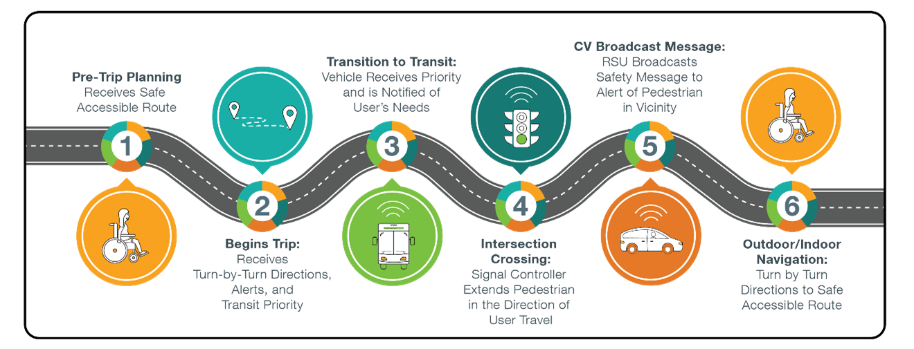
The traveler's complete journey with G-MAP unfolds seamlessly:
- Pre-Trip Planning: Travelers customize trip preferences based on specific needs.
- Trip Begins: Turn-by-turn directions align with defined preferences, with support services available if needed. Transit Signal Priority for buses can also be triggered to aid boarding and alighting.
- Transition to Transit: Transit vehicles receive priority, with drivers alerted to traveler requirements.
- Intersection Assistance: Travelers interact with signal controllers at intersections, ensuring safe crossings if they are unable to press the crosswalk button and provides the traveler with additional time to cross the intersection if needed.
- Connected Vehicles: Enabled connected vehicles are informed of the traveler's presence, enhancing safety.
- Indoor Navigation: Travelers enjoy hands-free indoor and outdoor navigation (at two major facilities) via G-MAP and wearables. This includes alerts, dynamic rerouting in response to path conditions, and updates on the status of indoor infrastructure such as elevators and escalators.
The ST-CTN initiative within the ITS4US Deployment Program represents a visionary approach to transportation accessibility. By leveraging cutting-edge technology and a commitment to inclusivity, this initiative will transform the travel experience for underserved communities. G-MAP is set to launch in Gwinnett County in 2024 with the potential to scale regionally and enable agencies to adapt the open source application to their unique deployment needs.